Las montañas del centro de México: un enigma fitogeográfico resuelto mediante análisis de similitud florística
José Luis Villaseñor *, Enrique Ortiz
Universidad Nacional Autónoma de México, Instituto de Biología, Departamento de Botánica, Apartado postal 70-233, 04510 Ciudad de México, Mexico
*Corresponding author: vrios@ib.unam.mx (J.L. Villaseñor)
Received: 07 October 2025; accepted: 29 March 2026
Abstract
Approximately 24.9% of the national territory is classified as mountainous, characterized by high floristic diversity and by the challenges in its biogeographic regionalization. The objective of this study was to determine whether the mountain ranges of central Mexico constitute a single phytogeographic province or comprise independent provinces. To resolve this enigma, a quantitative floristic analysis was conducted. Floristic composition was determined in 51 grid cells, each measuring 1° in latitude and longitude; subsequently, a floristic similarity analysis was performed using the β-Simpson index, followed by a cluster analysis to regionalize the study area. A total of 10,431 native species were documented in the mountains, representing 44.5% of Mexico’s entire flora. Of these, 3,723 species are exclusive to temperate regions, while 5,562 are also distributed in lowland tropical zones. Furthermore, 7,024 species endemic to the mountains were recorded. In resolving the enigma, 5 floristic provinces were identified, each supported by a significant number of endemic species, thereby demonstrating their distinct identity as biogeographic regions. The analysis presented here lends quantitative rigor to the traditionally qualitative debate regarding the regionalization of central Mexico’s mountains, thereby enabling an explicit comparison with previous proposals.
Keywords: Biogeography; Endemism; Floristics; Regionalization; Richness; Vascular plants
Resumen
Aproximadamente 24.9% del territorio nacional se clasifica como montañoso, se destaca por su gran diversidad florística y por los desafíos de su regionalización biogeográfica. El enfoque de este trabajo fue determinar si las sierras del centro de México forman una sola provincia fitogeográfica o constituyen provincias independientes. Para resolver este enigma se realizó un análisis florístico cuantitativo. Se determinó la composición florística en 51 celdas de 1° de latitud y longitud, y se realizó un análisis de similitud florística utilizando el índice β-Simpson para, posteriormente, regionalizar el área de estudio mediante un análisis de agrupamiento. Se documentaron 10,431 especies nativas en las montañas, lo que representa 44.5% de la flora total de México. De ellas, 3,723 especies son exclusivas de las regiones templadas, mientras que 5,562 también se distribuyen en zonas tropicales bajas. Se registraron 7,024 especies endémicas de las montañas. En la resolución del enigma se identificaron 5 provincias florísticas, cada una respaldada por un número significativo de especies endémicas, lo que demuestra su identidad como regiones biogeográficas. El análisis presentado aporta solidez cuantitativa al debate sobre la regionalización de las montañas del centro de México, tradicionalmente de carácter cualitativo, lo que permite contrastar explícitamente las propuestas previas.
Palabras clave: Biogeografía; Endemismo; Florística; Regionalización; Riqueza; Plantas vasculares
Introduction
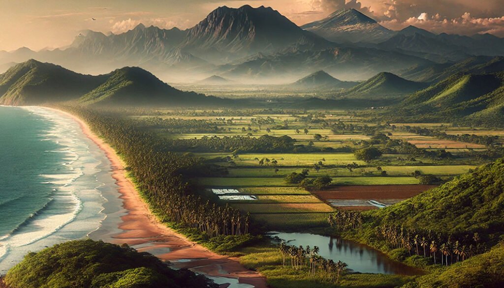
A mountain is any orographic feature that stands out from the plain, is surrounded by valleys, and is characterized by complex relief and steep slopes (Hoorn et al., 2018). This relief and slope can range from near sea level to high elevations with snowy peaks (Fig. 1). It is challenging to determine which parts of this extent can be appropriately called mountains; often, we refer to “mountains” only when considering the temperate forests typical of regions we call mountainous, which in Mexico are known as “sierras”. Mountains influence the organization of vegetation zones along altitudinal gradients, with each gradient displaying unique sets of species that are adapted to it (see, for example, Hernández-Rojas et al., 2020; Jiménez-López et al., 2020; Karger et al., 2011; McCain & Grytnes, 2010; Salas-Morales & Meave, 2012). However, the continuous nature of altitudinal gradients makes it difficult to define precise boundaries between mountains and lowlands.
One potential defining criterion could be elevation, but given this wide altitudinal gradient, how high should we consider a mountain? It is clear that, in general, elevation per se is not a reliable criterion for characterizing a mountainous area. For instance, in the state of Chiapas, tropical forests, which are rarely considered a mountain vegetation type, can occur at higher elevations than the same type of forest in Sinaloa or Sonora. Thus, although elevation is an informative parameter, it is not sufficient as a sole determinant of a mountain’s definition.
Rzedowski (1978) indicates that the tropical deciduous forest has the widest elevational distribution among tropical plant communities in Mexico, extending from sea level to 1,900 m, although it is more frequent below 1,500 m. A recent study of this forest type reports that its average upper elevation in the Balsas River Basin is 1,600 m (Flores-Tolentino et al., 2023). Thus, this is the elevation at which, on average, this vegetation type gives way to temperate forests, such as oak or pine forests, providing a general elevational threshold between mountain and lowland tropical forests.
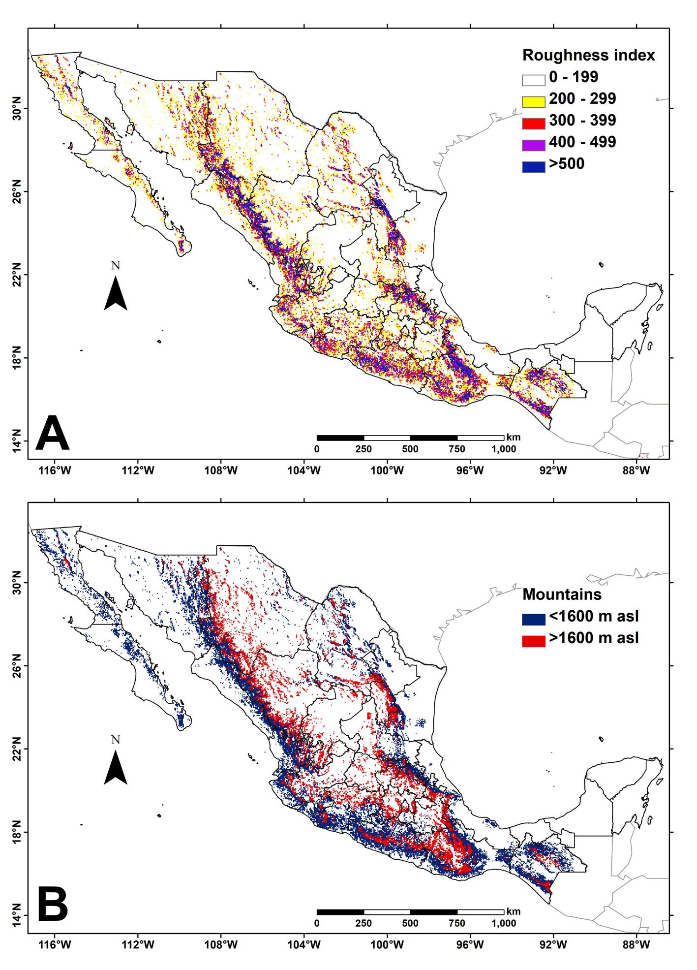
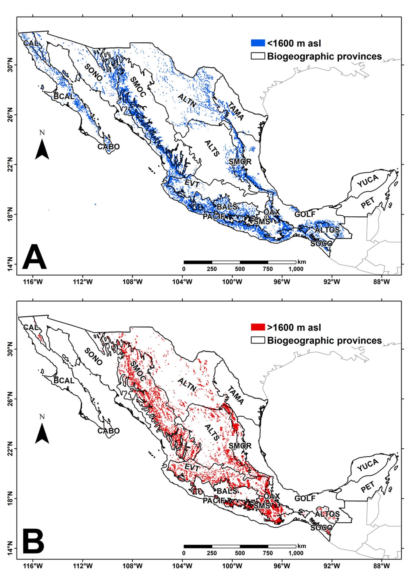
Perhaps a more rigorous way to define the boundaries of a mountain is to consider the specific relationships between its aspect or topography and altitude. One example is the roughness index, which quantifies the altitudinal difference in the terrain. For example, Körner et al. (2011) classify any terrain with a roughness index greater than 200 as a mountain. Figure 2A shows the roughness index values across Mexico, with white areas indicating values below 200, thereby categorizing them as flat regions. Figure 2B segregates all localities in the country with a roughness index above 200 into those above and below 1,600 m elevation, which marks the boundary between tropical plant communities typical of lowlands and temperate communities found at higher elevations (typically montane). Based on the roughness criterion (Fig. 2), 488,592.3 km² of Mexico’s area would be classified as mountains, representing 24.9% of the national territory. Of this area, 299,762.4 km² fall below 1,600 m elevation, while 188,829.9 km² are above that elevation.
Figure 3 illustrates the distribution of mountainous areas across Mexico’s biogeographic provinces (Conabio, 1997), highlighting regions located at elevations below or above 1,600 m. As noted, not all biogeographic provinces identified as mountain ranges (Sierra Madre Occidental, Sierra Madre Oriental, Sierra Madre del Sur, or Trans-Mexican Volcanic Belt) consist solely of mountainous areas. Most of the land classified as mountainous in Mexico consists of flat regions (valleys or plateaus) that do not genuinely qualify as mountainous territory. These flat areas, characterized by a roughness index of less than 200, are interspersed with sections classified as mountains, which have a higher roughness index. Therefore, it is not surprising that floristic elements with varying adaptive strategies and ecological and biogeographic affinities are found intermixed among valleys and slopes throughout a mountain range (Fig. 1).

The Trans-Mexican Volcanic Belt (TMVB, known in Spanish as the “Eje Volcánico Transversal”) is considered one of the most significant mountain ranges in central Mexico (Luna et al., 2008). Alongside the TMVB, several other crucial mountain ranges converge in this area: from the west, the Sierra Madre Occidental (SMOC, González-Elizondo et al., 2012) and the Sierra Madre del Sur (SMS, Luna-Vega et al., 2016); and from the east, the Sierra Madre Oriental (SMOR, Suárez-Mota et al., 2017; Salinas-Rodríguez et al., 2022; Villaseñor & Ortiz, 2022; Villaseñor et al., 2023) and the mountains of northern Oaxaca (OAX, Lorence et al., 2009). Each of these ranges possesses distinct floristic richness (see cited references) and many endemic species confined to their territory. Still, many species are shared across ranges, creating challenges in defining the biogeographical boundaries of each range.
Rzedowski (1978) emphasized the difficulties in defining the mountain ranges of central Mexico in his biogeographic regionalization. Consequently, he grouped them into a single unit, the Serranías Meridionales Floristic Province, which includes the TMVB, the Sierra Madre del Sur (SMS), and the complex montane system of Oaxaca (OAX). More recently, authors such as Conabio (1997) and Morrone (2019) have regarded each mountain range as an independent biogeographic province. However, there has not yet been a formal evaluation of which of these biogeographic proposals is more suitable for assessing diversity patterns in this region, a region of significant floristic richness and endemism. We therefore aimed to test 2 hypotheses in this context: First, based on floristic composition and number of endemisms, do the mountain ranges of central Mexico form a single phytogeographic province (Rzedowski hypothesis) or constitute independent provinces (Conabio or Morrone hypotheses)? Secondly, where are the geographic boundaries of the floristic units (districts, if a single province is accepted, or provinces, if each range is a separate province)?
To test these hypotheses, we defined the ecological affinities and geographic distribution of the species recorded throughout the central Mexican mountain ranges. The ecological affinities were determined by the degree of conservatism observed among species of the same genus in tropical or temperate environments, as well as by distribution, measured by the number of geographic units (OGUs) in which each species is recorded. We predict that each mountain range is characterized by several endemic species, as well as a set of species adapted primarily to temperate affinity.
Materials and methods
The first step was to determine the floristic composition of the central Mexican mountain ranges. For this purpose, we used shapefile maps of the biotic and biogeographic regions proposed by Ferrusquía-Villafranca (1990), Rzedowski and Reyna-Trujillo (1990), Conabio (1997), and Morrone et al. (2017). From each map, we delineated a polygon and subdivided it into 1° latitude-by-longitude squares, numbered according to a national schedule (see, for example, Cruz-Cárdenas et al., 2013, or Villaseñor et al., 2024) (Fig. 4). The various proposals regarding the mountains of the central region place their point of contact with the SMOR and SMOC at differing latitudes; therefore, to delineate the boundaries between the distinct mountain ranges within our analysis, we have slightly expanded the limits of each chain (TMVB, SMS, OAX) to encompass the southern limits of the SMOC to the west and the SMOR to the east. This approach resulted in 51 grid cells being used in the following analyses (Fig. 4).
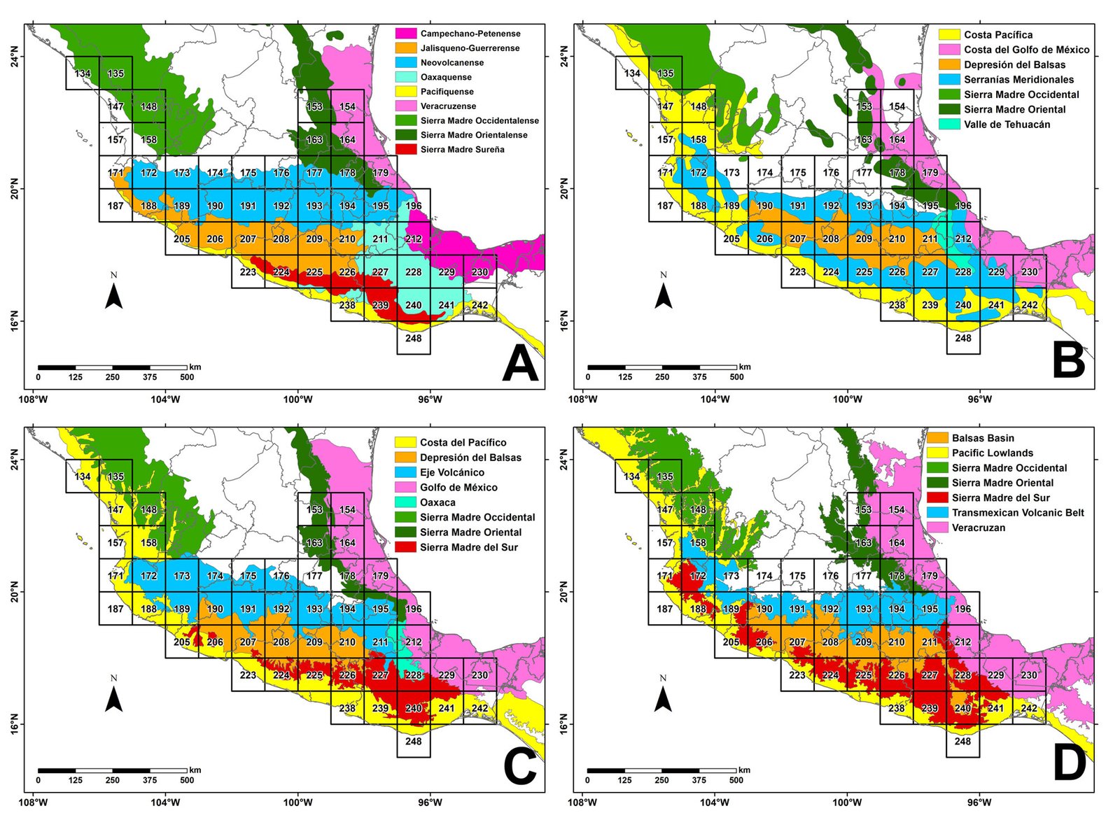
We determined the total number of native plant species (excluding introduced or exotic species) in each grid cell, enabling us to calculate alpha diversity per cell. Floristic information was compiled and entered into a database using the same strategy as in previous studies (Villaseñor & Ortiz, 2025). Introduced or exotic species were excluded at this stage, although most have already become naturalized and form part of the biodiversity of the mountain range ecosystems.
Once we had compiled the checklist of species in the mountainous regions of central Mexico, we compared the total number of species in the country with the number present in the mountain ranges for each genus. The ecological fidelity of the genus to tropical or temperate environments was assessed by examining the differences in species proportions within each genus across both environments nationwide. When more than 50% of species were recorded in tropical lowlands (Majority method; Murphy et al., 2019), we classified the genus as having a tropical affinity. In comparison, if more than 50% of species within the genus were found in mountainous regions, this indicated a temperate affinity. For instance, the genus Ageratina comprises 169 species, of which 154 (91.1%) are recorded from montane environments, indicating a temperate affinity. In contrast, the genus Bursera comprises 93 species in the country, of which 91 (97.8%) are recorded in the tropical lowlands, indicating a tropical affinity.
We used clustering analysis at the grid cell level to identify potential floristic regions (assemblages, floristic units, or phytochoria) and the main floristic elements (species) that characterize each floristic unit (Kreft & Jetz, 2010). To achieve this, the region was divided into 51 grid cells. We then used the species records to construct an incidence matrix for each grid cell and generated a β-Simpson dissimilarity matrix across grid cells. We used this index because it is not sensitive to differences in species richness among grid cells (Tuomisto, 2010). We then used the dissimilarity matrix to perform agglomerative clustering with the WPGMA method (weighted pair-group method using arithmetic means), which weights cluster contributions by the number of cells they contain, ensuring that each cell contributes equally to each agglomerate (González-Orozco et al., 2013). A threshold of 7 groups was determined to form phytochoria, corresponding to the regionalization of the study region proposed by Rzedowski and Reyna-Trujillo (1990; Fig. 4B). The clustering analysis was performed separately for the total flora and the tropical and temperate elements. Finally, we mapped and explored the floristic dissimilarities and identified agglomerates to identify grid cells with similar species assemblages. These analyses were performed in Biodiverse 4.3 (Laffan et al., 2010). We performed an Analysis of Similarities (ANOSIM) to assess whether the groups identified in the cluster analysis differ significantly in species composition. ANOSIM is a nonparametric technique that allows statistical comparisons between and within groups and tests the significance of differences among 2 or more groups of sampling units (Clarke & Green, 1988). The ANOSIM statistic “R” compares the mean of ranked dissimilarities between groups to the mean of ranked dissimilarities within groups. R varies from +1 to -1. R values greater than 0 indicate a higher dissimilarity between groups than within groups; R values equaling zero indicate an equal level of between-group and within-group average dissimilarity. Negative values of R indicate that dissimilarities within groups are greater than dissimilarities between groups (Clarke & Green, 1988). Chiarucci et al. (2019) classify R values as follows: sharp separability (R > 0.75); good separability (0.5 < R ≤ 0.75); and separated but overlapping (0.25 < R ≤ 0.5). These analyses were carried out in the R environment (R Core Team, 2025) with the vegan package (Oksanen et al., 2025).
Results
Taxonomic dispersion of the mountain flora of central Mexico. The total floristic richness of Mexico’s mountain ranges was 14,068 species (Villaseñor, unpublished data); this count excludes 490 known introduced or exotic species, most of which have become naturalized. The mountains of central Mexico contained records of 10,431 species, distributed among 1,816 genera and 256 families (Table 1), representing 74% of the country’s total native montane flora. Of these species, 3,723 are known to be distributed exclusively in the temperate regions of these mountain ranges (generally above 1,600 m elevation). At the same time, 5,562 are also distributed toward the lower tropical parts of the mountains. Asterids and Rosids account for most of this diversity, and Monocots are the third-most-represented group.
| Families | Genera | Species | |
|---|---|---|---|
| Ferns and monilophytes | 33 | 113 | 629 |
| Gymnosperms | 6 | 12 | 98 |
| Basal angiosperms | 2 | 3 | 3 |
| Magnoliids | 11 | 30 | 346 |
| Monocots | 33 | 362 | 2,273 |
| Eudicots | 10 | 27 | 91 |
| Rosids | 84 | 523 | 2,759 |
| Asterids | 77 | 746 | 4,232 |
| Total | 256 | 1,816 | 10,431 |
Species richness throughout the central Mexican mountains. Table 2 presents the species richness in each state in central Mexico, indicating the number of species exclusive to temperate regions and those whose distribution also includes lowlands with more tropical environments. The supplementary material comprises the species that constitute the exclusive mountain flora of central Mexico (3,723 species), indicating the states and grid cells where they are recorded. The state with the fewest number of species was Tlaxcala (991), and the richest was Oaxaca (6,846) (Table 2). The median number of species per state was 3,690. Similar richness patterns are observed among species typically found in highlands, with notable differences when considering widespread species (Table 2).
| State | Total species | Exclusive highlands | Distributed in tropical lowlands |
|---|---|---|---|
| Colima (COL) | 1,593 | 171 | 1,374 |
| Guanajuato (GTO) | 2,194 | 368 | 1,242 |
| Guerrero (GRO) | 4,707 | 1,103 | 3,255 |
| Hidalgo (HGO) | 3,690 | 771 | 2,176 |
| Jalisco (JAL) | 4,929 | 1,320 | 3,054 |
| Mexico (MEX) | 3,837 | 956 | 2,370 |
| Mexico City (CDMX) | 1,344 | 347 | 660 |
| Michoacán (MICH) | 4,180 | 1,022 | 2,719 |
| Morelos (MOR) | 2,534 | 474 | 1,780 |
| Nayarit (NAY) | 2,763 | 565 | 2,008 |
| Oaxaca (OAX) | 6,846 | 1,715 | 4,543 |
| Puebla (PUE) | 4,574 | 869 | 3,062 |
| Queretaro (QRO) | 3,096 | 535 | 1,856 |
| Tlaxcala (TLAX) | 991 | 236 | 455 |
| Veracruz (VER) | 5,702 | 1,155 | 3,870 |
| Total | 10,431 | 3,723 | 5,562 |
Table S1, in the Supplementary material, presents the species by grid cell for the mountainous region under study. The highest values occurred in grid cell 228, located in Oaxaca, and grid cell 147, on the border between Nayarit and Sinaloa, had the lowest richness. The median number of species per grid cell was 1,532 species.
Figure 5A illustrates the alpha diversity patterns across the central Mexican mountain ranges. There are major richness centers in the west and east of the region, particularly along the TMVB. Another significant grid cell with exceptionally high richness is in the OAX range, in northern central Oaxaca. There is another prominent grid cell in eastern-central Mexico, at the convergence zone between the SMOR and the TMVB.
Species ecological affinities. When comparing the total number of species recorded in the country (Villaseñor, 2016, and updates not published since then) with the number in the mountains under study, it is found that of the 10,431 species recorded, only 3,723 were exclusively distributed in the highlands (temperate) (Tables 2, 3). Of the 1,815 genera, 457 had temperate affinity, and 108 had tropical affinity, while the remaining 1,250 genera included species whose ecological range did not show precise fidelity to either environment. Table S2 (Supplementary material) presents examples of genera that primarily exhibited temperate or tropical affinity.
Some of the characteristic genera of temperate mountain regions are Salvia L. (330 species in all of Mexico, 176 found in temperate highlands, and 52 in tropical lowlands), Tillandsia L. (232, 129, and 69, respectively), Ageratina Spach (169, 126, 69), Quercus L. (159, 98, 28), and Stevia Cav. (116, 90, 21). On the other hand, Tetramerium Nees (26 species in all of Mexico, 3 found in temperate highlands, and 25 in tropical lowlands), Desmopsis Saff. (22, 3, and 21, respectively), Bourreria P. Browne (17, 2, 17), Pouteria Aubl. (14, 3, 14), or Mortoniodendron Standl. & Steyerm. (8, 1, 8) are examples of genera with more species found in tropical than temperate environments, despite having some highland species.
Floristic similarities. Figure 5 shows alternative interpretations of the regionalization of the mountain regions in central Mexico. In addition to the mountain ranges that were the focus of this study (TMVB, SMS, and OAX), we show some contiguous provinces. Figure 5B considers the complete temperate flora of central Mexico (N = 10,431 species), while Figure 5C only includes the set of species known exclusively from highland environments (above 1,600 m elevation) of the mountains (N = 3,723 species). Figure 5D includes only species that are considered tropical due to their distribution extending to the lower parts of the mountains, primarily in their most tropical and thermophilic environments (N = 5,562 species). ANOSIM indicated that the species composition among the groups identified in the cluster analysis differed sharply and significantly. For all species, R = 0.7621, p < 0.001; for exclusively temperate species, R = 0.7624, p < 0.001; for exclusively tropical species, R = 0.7606, p < 0.001.
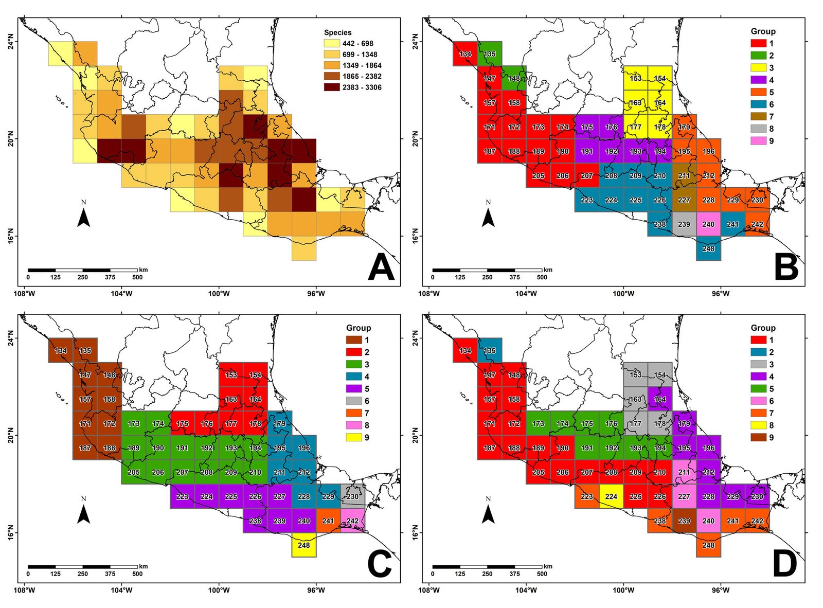
The groupings shown in Figure 5 align geographically with the previously defined provinces (Fig. 4). However, the mountainous regions become more evident when only the temperate flora is evaluated (Fig. 5C). In this case, the clustered grid cells define 5 phytogeographic regions, known as phytochoria. One is located towards the northwest (group 1), which characterizes the southern portion of the SMOC. The central one (group 3) defines the core of the TMVB, which converges towards the northeast with the SMOR (group 2). To the east, there is a sector corresponding to the Mexican Gulf slope formed by the eastern end of the TMVB and the OAX mountains (group 4). Finally, group 5 corresponds to the SMS. Four cells in the southeastern part of the study area did not group with the 5 phytochoria mentioned. Their isolation results from the small number of temperate-affinity species recorded in their territory (Supplementary material: Table S1).
Considering only species primarily distributed in the lowlands of the mountains (with a tropical affinity) yielded 7 clusters (Fig. 5D). One of these is the western region (group 1), which, in Figure 5C, is identified as the SMOC. This area now forms a continuous region that encompasses the SMOC, the southern part of the TMVB (group 3 in 5C), and a large portion of the SMS. Group 3 in this scheme corresponds to the SMOR (group 2 in 5B, C). Group 4 characterizes the lowlands of the Gulf of Mexico slope, and group 5 constitutes the core TMVB, sharing elements with the drier sectors of the southern Mexican highlands (ALTS, Fig. 3). The fifth group (group 6, Fig. 5D) encompasses a significant region of south Puebla and northern Oaxaca, known for its rich flora and numerous endemisms, specifically the Tehuacán-Cuicatlán Valley. Grid cell 240 is linked to this region (group 6) due to a small area with semiarid environments that recent explorations indicate have a strong floristic relationship with those to the north. Group 7 (Fig. 5D), located in southern Oaxaca, is considered an extension of the coastal grid cells of group 1, which characterize the Pacific floristic province (PACIF, Fig. 3). Grid cells 224 and 239 can be regarded as outliers of this continuous tropical lowland region.
Table 3 shows the floristic richness of each of the 5 floristic units (phytochoria) of the temperate mountainous region in central Mexico. Phytochoria 3 (TMVB), 4 (SE Mexico), and 5 (SMS) had higher species richness than Phytochoria 1 and 2 (SMOC and SMOR, respectively).
| Floristic group (Phytochorion) | Species | Endemic to Mexico |
|---|---|---|
| 1 (SMOC) | 1,244 (494) | 980 (452) |
| 2 (SMOR) | 908 (208) | 597 (184) |
| 3 (TMVB) | 1,614 (382) | 1,182 (346) |
| 4 (SE Mexico) | 1,385 (830) | 830 (283) |
| 5 (SMS) | 1,373 (558) | 976 (480) |
Discussion
The 10,431 species documented as the flora of the mountainous regions of central Mexico represent 44.5% of the 23,412 species reported in the latest assessment of Mexico’s complete flora (Villaseñor & Ortiz, 2025). This high percentage is undoubtedly essential, but it is more interesting that only one-third of this mountain flora is restricted to the highlands of the Sierras (Table 2). These values are undoubtedly explained by the small proportion of territory occupied by the mountain highlands (38.6% of the total mountain surface, as defined by a roughness index greater than 200).
The most represented groups in the mountainous flora of central Mexico are the Monocots, Rosids, and Asterids (Table 1), which corresponds with richness patterns at both the national and regional levels (Villaseñor, 2016; Villaseñor et al., 2023; Jiménez-López et al., 2023). These 3 groups were also dominant in species richness in evergreen tropical forests, which are characteristic of the country’s low, humid tropical regions (Villaseñor et al., 2025).
We recorded 7,024 Mexican endemic species in the central Mexican mountains. This represents 67.3% of total species richness, which is higher than the national average endemism rate (Villaseñor, 2016). Such a high level of endemism is unknown in any other region or ecosystem in the country. Similar levels of endemism have been observed in the country’s high-diversity taxonomic groups, such as Asteraceae (Villaseñor, 2018).
Interestingly, of the 3,723 species known to be exclusive to highland areas, 1,180 are endemic to Mexico. In addition, 978 of these endemic species are known only from such highlands. This low number of endemism restricted to the highlands suggests a wider species distribution, likely due to historical factors, as discussed by Mastretta-Yanes et al. (2015) for the TMVB.
Species ecological affinities. Our results show that genera considered typical of mountain environments, because they are distributed in areas with high roughness index values, are not necessarily restricted to temperate, montane-type environments; instead, they may include a significant number of species distributed in lower-elevation tropical environments. Likewise, in any grid cell in central Mexico, the number of montane species distributed across both the high and lower parts of the mountain ranges is as essential as that of species known only from the highest, most temperate parts (Table 2).
As mentioned above, only 35.7% of the total richness documented in the montane forests of central Mexico is restricted to the high-mountainous part; 53.3% of the species are distributed over a wider gradient, also occupying the lower parts of the mountains, where forests with tropical affinities predominate. These results should not surprise us, as indicated above, since the territory considered mountainous in Mexico, based on the roughness index criterion (which represents 24.9% of the national territory), is predominantly located below 1,600 m, where vegetation with a tropical affinity is commonly observed.
The ecological breadth of many genera (and their species) does not support the hypothesis of environmental conservatism, which posits stricter fidelity of descendants to their ancestors’ environments. Among the mountain flora studied, only 457 of 1,815 genera (25.2%) support this hypothesis, as most of their species exhibit an ecological preference for mountain/temperate environments. Similarly, on the lower slopes of the mountains, only 108 genera (5.9%) had a strictly tropical environmental affinity. The species of the other genera were relatively evenly divided between temperate and tropical preferences, thus showing no apparent genus-level affinity. A few studies have evaluated whether species’ distributions are restricted to temperate or tropical environments or span the elevational gradient (Hernández-Rojas et al., 2020; Jiménez-López et al., 2020; Salas-Morales & Meave, 2012). Further studies of this kind are needed to deepen our understanding of ecological conservatism among species.
Floristic similarities. The 5 groups identified for temperate species (Fig. 5C) align with well-established previous circumscriptions. For example, group 1 (in the northwest) corresponds with the southern edge of the SMOC and the piedmonts of the Pacific coast (PACIF) provinces. Group 2 corresponds with the southern part of the SMOR, along with the south edge of the Southern Highland (Altiplano Sur). Group 3 corresponds to the core of the TMVB, including lowlands oriented towards the Pacific and the Balsas (BALS) provinces. BALS is a tropical region that disjoints the TMVB and SMS (Flores-Tolentino et al., 2023; Villaseñor et al., 2021). Group 4 encompasses the easternmost edge of the TMVB, the southernmost part of SMOR, and the mountain system of northern Oaxaca (OAX). Finally, group 5 corresponds to the SMS, which begins in Guerrero and extends into central and southern Oaxaca (Fig. 5C). There are 4 grid cells considered to be outliers; cell 248 is easily assigned to the SMS, representing the lowlands of the Sierra oriented towards the PACIF province. The other 3 grid cells (230, 241, and 242) are located primarily in the lowland, where the elevation of the SMS and OAX decreases toward the characteristic lowlands of the Isthmus of Tehuantepec, where the lowland tropical provinces merge (Gulf of Mexico (GOLF) and Pacific (PACIF)). These cells likely represent part of the transition zone between the mountains of central Mexico and the mountain systems of Chiapas.
Our results do not support extending the delimitation of the SMS beyond the borders of Guerrero; the parts considered by Morrone (2019) as disjoint portions of this province in Michoacán and Jalisco are more floristically similar to the TMVB (Fig. 5C).
Biogeographic implications
Floristic regions are part of the Earth’s geography. They share a similar floristic composition, as defined by the number and distribution of species, genera, and families. Phytogeographic categories are determined using a hierarchical classification; for example, Takhtajan (1986) considers the kingdom, region, province, and district as the primary categories. Rzedowski (1978) used several of these to regionalize Mexico.
The region level is characterized by the occurrence of endemic genera and a high proportion of endemic species. Meanwhile, the province level exhibits less characteristic genus-level endemism, and the endemic genera present may include few or even a single representative species (Takhtajan, 1986). However, the most crucial factor in defining this province level is the floristic similarity among the geographical units (OGUs) that constitute it, which can be determined quantitatively (for example, using clustering methods) or statistically.
In the mountain ranges studied (Figs. 4, 5), 43 Mexican endemic genera are recorded. However, as with many species (Supplementary material: Table S2), several are not exclusive to temperate mountain regions but are also distributed in other biomes characteristic of the lower parts of the mountains. They may even extend into non-mountainous neighboring areas of adjacent floristic provinces that occupy sites within the grid cells included in the study area.
In phytochorion 1 (SMOC), no genus was restricted to the territory, as this part corresponds to the southern end of a floristic province that is better represented in the northwestern part of Mexico. Examples of endemic genera that are more widely distributed in the SMOC and whose southern limits fall within the study area include Bolanosa A. Gray and Pippenalia McVaugh. Phytochorion 2 (SMOR) contained the endemic genus Velascoa Calderón & Rzed., as well as 4 other near-endemic genera that are shared with the Southern Altiplano province and are found in more xeric environments (scrublands and grasslands): Chichimecactus Bárcenas, H.M. Hern. & P. Hern.-Led., Kroenleinia Lodé, Pseudonemacladus McVaugh, and Strombocactus Britton & Rose. In phytochorion 3 (TMVB), there was no typical genus from its temperate regions. However, a genus that occupies lowland mountainous areas, bordering the more tropical parts of the Balsas River Basin province, is Beiselia Forman. Phytochorion 4 (SE Mexico) is characterized by the genera Habroneuron Standl., Placocarpa Hook. f., and Stramentopappus H. Rob. & V.A. Funk, as well as Jeronimoa A. Vázquez, Islas & Rosales, which is also distributed towards more tropical and semi-arid areas. Phytochorion 5 (SMS) contains 2 endemic genera (Dahliaphyllum Constance & Breedlove and Eremitilla Yatsk. & J.L. Contr.). Five additional genera are documented at the foothills of the mountains, sharing temperate environments but more commonly found in more tropical ones towards the interior of the continent (Balsas River province) and on the Pacific Ocean slope (Pacific floristic province): Anotea (DC.) Kunth, Mexipedium V.A. Albert & M.W. Chase, Mezcala C.E. Hughes & J.L. Contr., Mixtecalia Redonda-Mart., García-Mend. & D. Sandoval, Petronymphe H.E. Moore, and Wimmeranthus Rzed.
To date, the genera mentioned above are known only from a single phytochorion; however, we have documented 23 additional endemic genera whose distributions are shared between 2 or more floristic groups. For example, the genus Davilanthus E.E. Schill. & Panero is documented from 4 phytochoria (TMVB, SE Mexico, SMOR, and SMS). Another 13 genera are known from 3 floristic groups, while 9 more occur in the territory shared by 2 phytochoria. In addition to the restricted genera, each of the 5 phytochoria identified in this study contains a significant number of characteristic species (Table 3). More importantly, each of them includes a substantial number of Mexican endemic species, many of which have restricted distributions within the phytochorion.
The large number of endemic genera restricted to this central mountainous region of Mexico supports Rzedowski’s (1978) hypothesis of treating it as a single phytogeographic unit (the Serranías Meridionales Province). However, each phytochorion, in addition to having one or more distinctive genera, includes significant numbers of restricted endemic species. Therefore, following Takhtajan’s (1986) proposal, each of them should be treated as a floristic province. There is no defined criterion for determining how many endemic species are required to establish a regionalization at the provincial level. Morrone (2019), for example, supports his regionalization with a few examples but does not indicate the total number of species characterizing each of his provinces. In this work, Table 3 indicates that each phytogeographic province contains more than 100 species restricted to its territory, supporting the idea that each should be treated as a distinct floristic province.
The 5 floristic provinces recovered in this study for the mountain system in central Mexico (Table 3) align most closely with the Conabio (1997) proposal. However, there are some differences in how parts of the SMS in Jalisco and Michoacán are classified as TMVB members. Similarly, Morrone’s (2019) regionalization includes the Sierras del Tuito and Manantlán in Jalisco (the Districts Jaliscience and Jalisco-Manantlán, respectively), as well as the Sierra de Coalcomán (District of Michoacán) in Michoacán, all of which form part of the SMS. In this study, the floristic data support classifying these districts as part of the TMVB rather than the SMS. Their placement within the TMVB is also consistent with the proposed geological evolution of the TMVB discussed by Ferrari et al. (2012).
The separation of species based on ecological preferences provides a more rigorous method for identifying floristic units in biogeographic regionalization. Most of the time, species with broad ecological tolerances are used as examples for particular environments, such as the temperate forest evaluated in this case. We recommend considering the species’ ecological affinities when evaluating further biogeographical proposals in the heterogeneous Mexican landscape.
The mountainous region of central Mexico is complex and difficult to characterize. Its orogenesis and the evolution of its biota have not been fully clarified, which, as noted above, has led to different biogeographical proposals. Using the floristic composition, we identified 5 floristic provinces, some of which have also been analyzed by other approaches as independent units, similar to those found here (Aragón-Parada et al., 2021, 2023; Suárez-Mota et al., 2013; Villaseñor et al., 2021).
We hope that analyses like the one presented here will motivate continued accumulation of data and analysis that will provide ever clearer insight into the origins of the rich biodiversity found in this important region of Mexico. However, equally important, this information enables us to clarify the limits of the floristic units that constitute the southern boundary of the significant Mexican Transition Zone (Villaseñor et al., 2020).
Acknowledgments
We thank Socorro González-Elizondo and Miguel Murguía-Romero for their helpful comments. We appreciate Lynna M. Kiere for reviewing the English version and her thoughtful comments.
References
Aragón-Parada, J., Rodríguez, A., Munguía-Lino, G., De-Nova, J. A., Salinas-Rodríguez, M. M., & Carrillo-Reyes, P. (2021). Las plantas vasculares endémicas de la Sierra Madre del Sur, México. Botanical Sciences, 99, 643–660. https://doi.org/10.17129/botsci.2682
Aragón-Parada, J., Carrillo-Reyes, P., Rodríguez, A., Munguía-Lino, G., Salinas-Rodríguez, M. M., & De-Nova, J. A. (2023). Spatial phylogenetics of the flora in the Sierra Madre del Sur, Mexico: Evolutionary puzzles in tropical mountains. Journal of Biogeography, 50, 1679–1691. https://doi.org/10.1111/jbi.14679
Chiarucci, A., Nascimbene, J., Campetella, G., Chelli, S., Dainese, M., Giorgini, D. et al. (2019). Exploring patterns of beta-diversity to test the consistency of biogeographical boundaries: a case study across forest plant communities of Italy. Ecology and Evolution, 9, 11716–11723. https://doi.org/10.1002/ece3.5669
Clarke, K. R. & Green, R. H. (1988). Statistical design and analysis for a ‘biological effects’ study. Marine Ecology Progress Series, 46, 213–226. https://doi.org/10.3354/meps046213
Conabio (Comisión Nacional para el Conocimiento y Uso de la Biodiversidad). (1997). Provincias biogeográficas de México, escala 1:4000000. México. Accessed January 15, 2025 from: http://www.conabio.gob.mx/informacion/gis/layouts/rbiog4mgw.png
Cruz-Cárdenas, G., Villaseñor, J. L., López-Mata, L., & Ortiz, E. (2013). Distribución espacial de la riqueza de especies de plantas vasculares en México. Revista Mexicana de Biodiversidad, 84, 1189–1199. https://doi.org/10.7550/rmb.31811
Ferrari, L., Orozco-Esquivel, T., Manea, V., & Manea, M. (2012). The dynamic history of the Trans-Mexican Volcanic Belt and the Mexico subduction zone. Tectonophysics, 522–523, 122–149. https://doi.org/10.1016/j.tecto.2011.09.018
Ferrusquía-Villafranca, I. (1990). Provincias bióticas (con énfasis en criterios morfotectónicos). Escala 1:4 000 000. In Regionalización biogeográfica. Atlas Nacional de México. Vol. II. Instituto de Geografía, UNAM. México. Accessed January 15, 2025 from: http://www.conabio.gob.mx/informacion/gis/?vns=gis_root/region/fisica/rmorf4mgw
Flores-Tolentino, M., Ramírez-Rodríguez, J. R., Morales-Linares, J., Ibarra-Manríquez, G., Dorado, O., & Villaseñor, J. L. (2023). Delimitación geográfica y florística de la provincia fisiográfica de la Depresión del Balsas, México, con énfasis en el bosque tropical estacionalmente seco. Revista Mexicana de Biodiversidad, 94, e944985. https://doi.org/10.22201/ib.20078706e.2023.94.4985
González-Elizondo, M. S., González-Elizondo, M., Tena-Flores, J. A., Ruacho-González, L., & López-Enríquez, I. L. (2012). Vegetación de la Sierra Madre Occidental, México: una síntesis. Acta Botanica Mexicana, 100, 351–403. https://doi.org/10.21829/abm100.2012.40
González-Orozco, C. E., Laffan, S. W., Knerr, N., & Miller, J. T. (2013). A biogeographical regionalization of Australian Acacia species. Journal of Biogeography, 40, 2156–2166. https://doi.org/10.1111/jbi.12153
Hernández-Rojas, A. C., Kluge, J., Krömer, T., Carvajal-Hernández, C., Silva-Mijangos, L., Miehe, G. et al. (2020). Latitudinal patterns of species richness and range size of ferns along elevational gradients at the transition from tropics to subtropics. Journal of Biogeography, 47, 1383–1397. https://doi.org/10.1111/jbi.13841
Hoorn, C., Perrigo, A., & Antonelli, A. (2018). Mountains, climate, and biodiversity: an introduction. In C. Hoorn, A. Perrigo, & A. Antonelli (Eds.), Mountains, climate and biodiversity (pp. 1–13). Newark: Wiley-Blackwell.
Jiménez-López, D. A., Martínez-Camilo, R., Martínez-Meléndez, N., & Kessler, M. (2020). Diversity of epiphyte ferns along an elevational gradient in El Triunfo Biosphere Reserve, southern Mexico. Plant Ecology and Evolution, 153, 12–21. https://doi.org/10.5091/plecevo.2020.1759
Jiménez-López, D. A., Gallardo-Cruz, J. A., Véliz, M. E., Martínez-Camilo, R., Méndez, C., Solórzano, J. V. et al. (2023). High vascular plant species richness in the Usumacinta River Basin: a comprehensive floristic checklist for a natural region in the Mesoamerican biodiversity hotspot. Botanical Sciences, 101, 908–930. https://doi.org/10.17129/botsci.3253
Karger, D. N., Kluge, J., Krömer, T., Hemp, A., Lehnert, M., & Kessler, M. (2011). The effect of area on local and regional elevational patterns of species richness. Journal of Biogeography, 38, 1177–1185. https://doi.org/10.1111/j.1365-2699.2010.02468.x
Körner, C., Spehn, E. M., & Paulsen, J. (2011). A definition of mountains and their bioclimatic belts for global comparisons of biodiversity data. Alpine Botany, 121, 73–78. https://doi.org/10.1007/s00035-011-0094-4
Kreft, H., & Jetz, W. (2010). A framework for delineating biogeographical regions based on species distributions. Journal of Biogeography, 37, 2029–2053. https://doi.org/10.1111/j.1365-2699.2010.02375.x
Laffan, S. W., Lubarsky, E., & Rosauer, D. F. (2010). Biodiverse, a tool for the spatial analysis of biological and related diversity. Ecography, 33, 643–647. https://doi.org/10.1111/j.1600-0587.2010.06237.x
Lorence, D., Ramírez-de Anda, M., Torres-Colín, R., & Villa-Arce, R. (2009). Listados florísticos de México. XXV. Flora de la Sierra de Juárez, Oaxaca: Distrito de Ixtlán y áreas adyacentes (Sierra Norte de Oaxaca). Ciudad de México: Universidad Nacional Autónoma de México.
Luna-Vega, I., Espinosa, D., & Contreras-Medina, R. (2016). Biodiversidad de la Sierra Madre del Sur, una síntesis preliminar. Ciudad de México: Universidad Nacional Autónoma de México.
Luna, I., Morrone, J. J., & Espinosa, D. (2008). Biodiversidad de la Faja Volcánica Transmexicana. México D.F.: Universidad Nacional Autónoma de México/ Comisión Nacional para el Conocimiento y Uso de la Biodiversidad.
Mastretta-Yanes, A., Moreno-Letelier, A., Piñero, D., Jorgensen, T. H., & Emerson, B. C. (2015). Biodiversity in the Mexican highlands and the interaction of geology, geography, and climate within the Trans-Mexican Volcanic Belt. Journal of Biogeography, 42, 1586–1600. https://doi.org/10.1111/jbi.12546
McCain, C. M., & Grytnes, J. A. (2010). Elevational gradients in species richness. Encyclopedia of Life Sciences (Eds.), (pp. 1–10). John Wiley & Sons. https://doi.org/10.1002/9780470015902.a0022548
Morrone, J. J. (2019). Regionalización biogeográfica y evolución biótica de México: encrucijada de la biodiversidad del Nuevo Mundo. Revista Mexicana de Biodiversidad, 90, e902980. https://doi.org/10.22201/ib.20078706e.2019.90.2980
Morrone, J. J., Escalante, T., & Rodríguez-Tapia, G. (2017). Mexican biogeographic provinces: map and shapefiles. Zootaxa, 4277, 277–279. https://doi.org/10.11646/zootaxa.4277.2.8
Murphy, D. J., Ebach, M. C., Miller, J. T., Laffan, S. W., Cassis, G., Ung, V. et al. (2019). Do phytogeographic patterns reveal biomes or biotic regions? Cladistics, 35, 654–670. https://doi.org/10.1111/cla.12381
Oksanen, J., Blanchet, F. G., Friendly, M., Kindt, R., Legendre, P., McGlinn, D. et al. (2025). “Vegan: community ecology package”. R Package Versions 2.6-8 and 2.7-1. https://cran.r-project.org/web/packages/vegan/
R Core Team (2025). R: a language and environment for statistical computing. R Foundation for Statistical Computing, Vienna, Austria. https://www.R-project.org/
Rzedowski, J. (1978). Vegetación de México. México D.F.: Limusa.
Rzedowski, J., & Reyna-Trujillo, T. (1990). Atlas Nacional de México. Vol. II. Divisiones florísticas. Escala 1:8000000. En Instituto de Geografía (Ed.). México D.F.: Universidad Nacional Autónoma de México. Accessed January 15, 2025, from: http://www.conabio.gob.mx/informacion/gis/?vns=gis_root/region/biotic/pfito8mgw
Salas-Morales, S. H., & Meave, J. A. (2012). Elevational patterns in the vascular flora of a highly diverse region in southern Mexico. Plant Ecology, 213, 1209–1220. https://doi.org/10.1007/s11258-012-0077-6
Salinas-Rodríguez, M. M., Hernández-Sandoval, L., Carrillo-Reyes, P., Castillo-Gómez, H. A., Castro-Castro, A., Estrada-Castillón, E. et al. (2022). Diversidad de plantas vasculares de la provincia fisiográfica de la Sierra Madre Oriental, México. Botanical Sciences, 100, 469–492. https://doi.org/10.17129/botsci.2864
Suárez-Mota, M. E., Téllez-Valdés, O., Lira-Saade, R., & Villaseñor, J. L. (2013). Una regionalización de la Faja Volcánica Transmexicana con base en su riqueza florística. Botanical Sciences, 91, 93–105. https://doi.org/10.17129/botsci.405
Suárez-Mota, M. E., Villaseñor, J. L., & López-Mata, L. (2017). Dominios climáticos de la Sierra Madre Oriental y su relación con la diversidad florística. Revista Mexicana de Biodiversidad, 88, 224–233. https://doi.org/10.1016/j.rmb.2017.01.020
Takhtajan, A. (1986). Floristic regions of the world. Berkeley: University of California Press.
Tuomisto, H. (2010). A diversity of beta diversities: straightening up a concept gone awry. Part 1. Defining beta diversity as a function of alpha and gamma diversity. Ecography, 33, 2–22. https://doi.org/10.1111/j.1600-0587.2009.05880.x
Villaseñor, J. L. (2016). Checklist of the native vascular plants of Mexico. Revista Mexicana de Biodiversidad, 87, 559–902. https://doi.org/10.1016/j.rmb.2016.06.017
Villaseñor, J. L. (2018). Diversidad y distribución de la familia Asteraceae en México. Botanical Sciences, 96, 332–358. https://doi.org/10.17129/botsci.1872
Villaseñor, J. L., Encina-Domínguez, J. A., Estrada-Castillón, E., Hinton, G. S., Mora-Olivo, A., Ortiz, E. et al. (2023). Diversidad florística de la región noreste de México, estados de Coahuila, Nuevo León y Tamaulipas. Botanical Sciences, 101, 1301–1319. https://doi.org/10.17129/botsci.3328
Villaseñor, J. L., & Ortiz, E. (2022). A phytogeographic assessment of the Sierra Madre Oriental physiographic province, Mexico. Botanical Sciences, 100, 1102–1123. https://doi.org/10.17129/botsci.3086
Villaseñor, J. L., & Ortiz, E. (2025). Floristic richness comparison among the Mexican states. Revista Mexicana de Biodiversidad, 96, e965505. https://doi.org/10.22201/ib.20078706e.2025.96.5505
Villaseñor, J. L., Ortiz, E., Delgadillo-Moya, C., & Juárez, D. (2020). The breadth of the Mexican Transition Zone as defined by its flowering plant generic flora. Plos One, 15, e0235267. https://doi.org/10.1371/journal.pone.0235267
Villaseñor, J. L., Ortiz, E. & Juárez, D. (2021). Transition zones and biogeographic characterization of endemism in three biogeographic provinces of central Mexico. Botanical Sciences, 99, 938–954. https://doi.org/10.17129/botsci.2768
Villaseñor, J. L., Ortiz, E., & Meave, J. A. (2025). Floristic diversity of the Tropical Rainforest in Mexico. Botanical Sciences, 103, 899–916. https://doi.org/10.17129/botsci.3681
Villaseñor, J. L., Ortiz, E., & Murguía-Romero, M. (2024). The rarest of rarities in the flora of Mexico. Botanical Sciences, 102, 1300–1317. https://doi.org/10.17129/botsci.3498